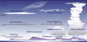
The Types of Clouds
Have you ever been watching the clouds move across sky and wondered what you were actually looking at? Do all the names of these clouds seem to sound the same? You are not alone, however, today we are going to alleviate this confusion. Clouds are normally identified by their elevation in the sky and their physical appearance. There are 10 major distinctions of clouds that will cover most patterns you see in the sky. Below are photos and descriptions associated with each cloud type:
 Low Elevation Clouds
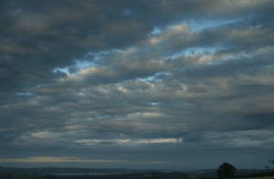 Stratocumulus
Below 6,000 feet
Stratocumulus are low lying, white, stretched, puffy clouds that may appear dark in places. These clouds are similar to your average cumulus cloud; however, they are much larger and can appear darker.
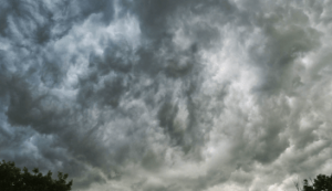 Nimbostratus (rain)
Below 6,500 feet
When you see nimbostratus clouds you are almost surely being rained on or will be rained on. These dark, thick clouds lay at mid to low levels because they are weighed down with water concentration.
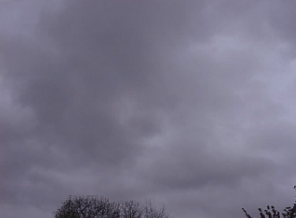 Stratus
Below 6,000 feet
Like fog, stratus clouds lay very low in the sky and have very little structure. Stratus clouds are great movie days associated with mist, spit, or a light drizzle. Although stratus clouds look like fog, they are higher in the atmosphere, normally lining the horizon.
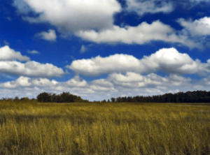 Cumulus (fair weather)
Below 6,000 feet
If you picture yourself having a picnick on a beautiful day. Now look up. If you are seeing clouds on this beautiful day, you are probably envisioning cumulus clouds.The classic white, puffy cloud with a rounded top and a flat bottom.
Mid Elevation Clouds
 Altostratus
Between 6,000-20,000 feet
Altostratus clouds are reserved for those hazy days when the dark blue-grey clouds seem to engulf the sky. Sometimes the sun or moon will shine through and appear fuzzy.
 Altocumulus
Between 6,000- 20,000 feet
Altocumulus are the classic cotton ball clouds. These puffy, white clouds are the most common mid-level clouds and sometimes signal that a storm is on the way.
High Elevation Clouds
 Cirrostratus
Above 18,000 feet
Cirrostratus clouds are spread across the entire sky and almost seem transparent. This wispy cloud formation signals that there is warm weather ahead.
- Cirrus
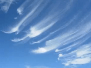
Above 18,000 feet
Cirrus clouds are extremely common year-round on clear days. At their high altitude, ice crystals are spread apart as if they are painted across the sky. Less widely spread as cirrostratus clouds and more
- Cirrocumulus
Above 18,000 feet
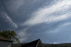
Cirrocumulus clouds are similar to cirrus clouds in height, however, they appear more splotched than stretched. To elaborate, cirrocumulus clouds are groupings of packed ice crystals (cloudlets) that are more uniform than their sister cirrus clouds.
Both Low and High Elevation
- Cumulonimbus (thunderheads)
Near ground level to above 50,000 feet

Cumulonimbus are the clouds most closely compared to what you would imagine a thunderhead would look like. These giant billowy towers are composed of water droplets in its’ base and ice crystals towards the upper levels. Cumulonimbus clouds almost always signal that there is a thunderstorm happening.
Web Sources
https://www.thoughtco.com/types-of-clouds-recognize-in-the-sky-4025569
https://scied.ucar.edu/webweather/clouds/cloud-types